Tuesday, September 30, 2014

Day 21

Tuesday, September 30

First, we like to say how happy we are that our friend Ron has left the hospital after a very long stay away from home up in NY!

Second, greetings to Manfred in Kassel, Germany.    Manfred: "Hoch die Tassen!" with our coffee cups!

We'd hoped to spend the day seeing all the classic sites in the Teton and Yellowstone National Parks. Alas, the rain and clouds intensified.    We traveled under the shadow of the Tetons and saw only a tiny bit of snow on the slopes as the mountains were 90% covered by gray clouds.   I'd seen the Tetons back in the summer of '78, a truly remarkable site!   Very unhappy that Linda did not see them on this trip.

We first passed through the trendy tourist center of Jackson, WY, and saw several of the elk antler arches.   We learned that Jackson is the original home of "dude ranching" in the USA.   Ranchers learned that there is much more money in horse tours for wealthy Easterners than there is in chasing cows or raising potatoes.   Today, this rather small town has a nice airport for private jets!

Rain-splattered window.


We stopped by the Teton Visitor Center and learned about the history, geology, etc.


Teton Visitor Center with Moose Statue.

We traveled north across the western Continental Divide into Yellowstone National Park.   Back in the Missouri watershed!  

We fairly quickly saw a nice herd of large antelope but did not get a photo.    Then came the biggest surprise of the day.    It was raining fairly hard and we saw a group of oncoming cars grouped behind an animal.     At first, I thought it was a small deer, then thought it was a coyote.    When we were fairly close and I came almost to a halt to avoid hitting it, we could see it was a large wolf...streaming water and not much worried about the traffic!

Wolf partially obscured by wiper blade.

Well into the park, we encountered another first for us, an elk grazing in the forest!

One of the famous geothermal "steam pots" by the lake.

Lewis Falls.

After seeing that the forecast for tomorrow was for snow in Yellowstone, we decided to move on East and try to find a place to stay near Cody.    We headed for the East Entrance to the park.   Along the way, we saw a large mule deer doe.

As we left we saw Mount Cody.

We went over a pass at about 8500 feet and descended to drive along the Shoshoni River in the Shoshoni National Forest.   There are many interesting and beautiful rock formations along the river.   This is a very active area for guided horseback tours.   We saw dozens of horse trailers parked at trailheads.


The rain finally let up after we entered Cody, where we have set up for the night.   The day was somewhat of a disappointment but we did have the peak experience of seeing a wolf in the wild (sort of) and several other kinds of wildlife.

Linda Adds:  I have to admit to being somewhat disappointed to have missed Old Faithful but the weather was not cooperating.  Snow had closed the shorter route in and is forecast for tomorrow...not the best thing to drive with a trailer in tow.  The Tetons were beautiful and the wildlife amazing despite the weather.  Never leave home without a jacket!  Wyoming is the 10th largest state in the Union but by population is last!  So if you crave beautiful scenery without having to share too much...only crazy tourists...come to Wyoming.

Monday, September 29, 2014

Day 20

Monday, Sep 29

Long drive today, we crossed Idaho from Oregon on I84 and I86 and are now in Jackson, Wyoming.    Too far in one day with the trailer.

Was a very gray day with low clouds and occasional rain.   There's probably some nice scenery but we missed most of it.

Followed the Snake River from the Oregon/Idaho border all the way to our campsite in Wyoming.

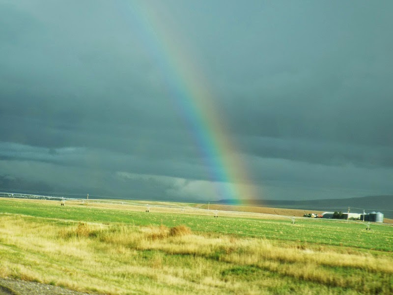
There was a nice rainbow once, when the sun popped through.


The Snake River becomes exceptionally beautiful as it hooks in a huge U where it enters Wyoming.   It is hemmed in by mountains and reminds us of rivers in the Alps like the Isar or the Inn.    The little town of Alpine, WY, tries to look like Austria so its a nice effect.

The Snake River is dammed and a fairly large lake exists a little below Jackson, WY.

Arrived after dark, so we are fairly tired.  Even Stella just wants get get on her bed and snooze!

Tomorrow, the Tetons and Yellowstone.

Linda Adds:  It was a lovely drive across Idaho....actually saw harvested potatoes...despite a smattering of rain.  Of course, the real beauty is in the Tetons.  Snake River stands up to it's name as it meanders across Idaho and into Wyoming.  The temperatures have dropped and it is nice to have heat in the trailer tonight.


Sunday, September 28, 2014

Day 19

Sunday, September 28

Had to say farewell to brother Joe at the campsite in Hammond.   Sure was great to see him and spend a little time together!

Drove through Portland and continued east on I-84.   Managed to glimpse Mount Hood twice through the large patches of fog, once from the west and once from the east in the rear view mirrors.   Extraordinary mountain.    Thumbnail photo from Wikipedia.  Please read the full article there and see larger photos.


Many more wind turbines along the Columbia Gorge.    We've now seen over a thousand, by estimate.   Your tax money at work...

I-84 leaves the Columbia Gorge out near Umatilla and turns SE toward Pendleton.   The area in between is flat and arid.   Almost no crops.   Mostly plains covered by grass.
At Pendleton, we crossed the Umatilla River and the terrain changes again.
Across the river is the Umatilla Indian Reservation and the Blue Mountains.    Trees again appear.
Some of the Blue Mountains are over 8000 feet.
We settled into our campsite near the Powder River and watched an excellent sunset.   God does incredible work with color!

I believe Mt Ireland is the peak on the left.  8321 ft.


As we left the west coast we psyched ourselves up to return to the Blue Ridge by listening to our western NC David Holt's rendition of "Dixie" and then "Whistling Asheville Blues".    As we moved onto the plains, Dido added her original "This Land is Mine".  

Day 18

Saturday, September 27

Did lunch and afternoon in Astoria, Oregon.   It is an old fishing town just inside the Columbia estruary.   Also known as Goonietown, because "The Goonies" was filmed there.   Many people come out from Portland for afternoons or weekends.

Met Linda's friend Susan and had lunch in a Fish and Chips pub.   Linda and Susan attended middle and high school together in Kentucky a few years ago.   Was great to see Susan!


Brother Joe also arrived and had lunch.


We walked through Astoria and visited the exceptional good maritime museum.   Really good exhibits about the treacherous Columbia River bar (where the river current meets the high waves of the Pacific).

Later that evening, we raised a cup of cheer to the success of the trip and happy reunions by using the nice bottle contributed by my wonderful sister, Mary Hope!


The next day would begin our trip back East.

Linda Adds:

It was great to reconnect with high school friend, Susan.  We hadn't seen each other since college days.  Our high school class had only 20 students graduating and the school was closed that year.
Also nice to see Stan's brother, Joe, who we don't get to see nearly as often as we would like.

Astoria is a very interesting town, founded as a fur trading fort in 1811, such a short time after Lewis and Clark visited there.  It was the first permanent location established in the area and named for John Astor who owned Pacific Fur Company.  The other claim to fame is in the late 1800's, seven cannery men opened Bubble Bee Cannery.  They continue to can and distribute tuna and salmon today.

The maritime museum was very interesting.  Had not realized how dangerous the confluence of the Columbia with the Pacific is.  It is the scene of many ship wrecks.  I can only imagine the difficulty Lewis and Clark's team had in crossing this area by dugout canoe from their initial camp, Cape Disappointment on the north side to the south side where they established Fort Clatsop.

Friday, September 26, 2014

Day 17, END OF THE TRAIL

Friday, September 16, 2014

A day we've planned for and been anticipating for a long time...

The Expedition had worked much harder for this day than we.     How many million steps, how many million oar and paddle strokes to cover over 3000 miles of river and trail?  They hoped to find a US or British ship in the Columbia River estuary.  But, sailors knew to not be on this coast in the autumn or winter.   Far too much wind and rain and a lee shore.   So, the Expedition settled in to wait out the winter.

A special hello to several of our friends reading this blog:  Ron, up in NY, and Doug in VA.  

Rained all night here and was typical NW Oregon rain as we headed for Fort Clatsop.

Arrived at the site and found a nice Interpretive Center.

This museum concentrated almost totally on the time that Corps of Discovery spent on this wet peninsula, their preparations for the trip back, and their relationships with the local tribes.

Inside, we watched a well-done video and went through all the displays and gift shop.  A full-size statue of Lewis and Clark speaking with a local tribal chief dominated one area.

Outside, a statue of Sacagawe and little Pompey/Jean Baptiste.     Jean Baptiste Charbonneau was later adopted by William Clark after the death of his mother, was well-educated, lived a number of years in Europe, and died here in Oregon.

We slowly walked down the trail to Fort Clatsop, our objective for 17 days...   There it was.
Great to be here.   A 15 stars,15 stripes United States flag flies over the reconstructed fort, just as it did every day while the Corps of Discovery was here.   Then, as now, the flag had a very special meaning for these soldiers.  


Next, we went to Seaside, Oregon, to see the place where the the Corps of Discovery were at their westernmost position, the End of the Trail.    The rain and wind increased steadily and were almost torrential.


By now, we feel a strong bond, not only with these two leaders, but with the entire Corps of Discovery.    We know who we'd like to talk to, who is the best shot, who is the best fisherman, and who can best paddle a canoe or play the fiddle.    We've read books about them, shared their trail and campsites.   They live on in history and in the culture of the United States of America.


We decided we had to walk across the beach to the Pacific.    Winds were above 40 mph and we were laughing at how wet we'd become.


Unlike the good folks of the Expedition, we then took shelter in a coffee shop.   Revived, we traveled back to our campsite and suddenly the weather changed for the better.   The rain stopped and the sun emerged.

____________________________________________________________________________

Fort Stevens (dating to the  US Civil War) was across the road from our campground so we walked about 1.5 miles to the beach with Stella, the wonder dog.   Fort Stevens helped secure the approaches to the Portland harbor.

Wreck of the Peter Ireland, from 1906.

Looking north, toward the Columbia River.

Stella enjoying the beach.

Stella on driftwood.

Stella wanted to go into the water, too, so....back into the drink!  She now believes that the Pacific is one cold bathtub!

Team Yertle, Trail's End.

Linda adds:

It has been a wonderful adventure.  I am particularly proud of the fact that nine of the Corp of Discovery were Kentucky men and William Clark also came from Louisville, home of my family.
I have learned more about Lewis and Clark and the people (and dog) who traveled with them; the indians they met; Sacajawea and so much more.  The Flathead indians near this coastal site were very interesting.

This picture was from William Clark's journal depicting these Indians' flathead and the means by which they achieved this look, which they found very desirable....infants would be placed in a sort of press while their bones were still soft.  

The Clatsop and Chinook tribes made much of their clothing from woven cedar strips to include grass skirts and a conical hat to deflect the rain.  I would have liked to have had one of those out on the beach today.  They were good traders of various goods and had some experience with other Americans and other Europeans from ships that sailed up the coastline.  They thought these white people were bear-like because of their hairy faces.

Our journey west is drawing to an end, but keep tuned.  The adventure will continue as we move homeward, just as the Expedition's did in route back to St. Louis.


Thursday, September 25, 2014

Day 16

Thursday, September 25

Short entry today.

Traveled from Hood River to Portland, then across the Columbia River to follow I-5 northwest.   At Longview, WA, we recrossed the river and drove US 30 to Astoria.  

The rain and winds arrived in strength as we situated the travel trailer so we are staying put for the evening.   Beans, rice, and apple turnovers.

Tomorrow we visit Fort Clatsop and the Pacific coast, both just a short distance away.

We are both very tired but happy to have arrived at our destination!

Astoria and the Columbia River just before the rain.  
AKA, "Gooneytown".

Day 15

Wednesday, September 24

No, we have not had a terrible accident.  Sorry the blog did not get done yesterday.  We spent the day driving across Washington and into Oregon, at last.  Had our first view of the Columbia River.  Stan's brother, Joe, is staying in the area.  Met him in Cascade Locks, Oregon and had a lovely dinner and breakfast.  But instead of blogging, we were chatting.  We will update with more information this evening.

Added on Sept 25:

After leaving Clarkston, Washington, we drove across the Palouse Prairie to the Columbia River.   The Palouse is a huge wheat and soybean region.   Very large rolling hills.   This area is in the rain shadow of the Cascade Mountains and so is a semi-arid steppe, using fancy geographical terms.

NOTE: you can double-click the photos to enlarge them.


Near the eastern edge we encountered this nice US flag that was somehow done on a cut wheatfield.  Excellent oldies stations and patriotism.   Nice small towns.  Good area.

Near Dayton, Washington, there's a recreation of a Corps of Discovery campsite.   The campsite was during the return trip east in the spring of 1806, as the river current was too strong to use canoes going upstream   The figures are lifesize silhouettes and done in COR-TEN steel.    In this setting, has a lot of impact.

Closer..

Note little Pompey/Jean-Baptiste by the fire with Lewis, Clark, and Seaman, the dog, in the foreground.


Explanation of the routes taken by the Corp in this region of Washington State.

After Walla Walla, we met the great Columbia River and followed it downstream.   Lots of wind in the gorge!    Dry, barren hills.   The fall/winter rains were about to begin and we met a huge front with the first rain this area has experienced in many weeks.

Union Pacific train.

After we passed The Dalles, the climate changed and we began encountering more trees which soon become the great rain forest of the NorthWest.


We spent the night not far from the Hood River and Mount Hood.

It was great to see my brother who joined us at our campsite!